

Black diamond trails for hiking

Bella Vista, Arkansas · Hiking & photography
Some trails deserve a slower look.
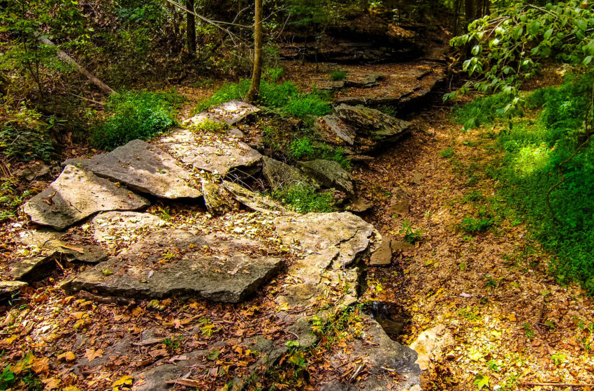
Some of Bella Vista’s technical mountain-bike trails make rewarding hikes for people comfortable on rocky ground. They can lead into quieter corners of the woods, with rock formations and creek scenery worth taking time to explore.
A black diamond describes the challenge of riding the trail. On foot, some riding obstacles are easier to negotiate, but footing, steep sections, and exposed edges still matter. So does the distance it takes to get there.
Build the rest of your visit around the Bella Vista Getaway Guide 2027.
Plan the whole outing.
Bella Vista’s trailheads are woven into the community. Once you set out, though, a rocky hollow or bluff section may sit well inside the network. Reaching places such as Danger Will Robinson or the Staggerwing area is part of the adventure.
Count the approach, the section you want to explore, and the return. A named trail’s listed mileage is only one part of your outing. Add climbing and time for photographs to your plan.
| Class 1 e-bike | Pedal assistance can make the approach climbs more manageable. Match the route to your riding skills and leave enough battery for the return. |
|---|---|
| Pedal bike | A practical option for riders comfortable with repeated climbs. Fitness matters: even a blue-rated connecting trail can take substantial effort. |
| On foot | Allow more time for the approach and return. Choose a destination that leaves you energy to enjoy the interesting section once you arrive. |
Start with the Trailblazers trail maps to plan from a public parking area. For pedal-assist access, check the City’s Class 1 e-bike guidance.
Three black-diamond trails to explore
These shared trails are in Bella Vista’s Little Sugar system and are listed for hiking. Use their maps to build a complete outing from your chosen starting point.
Rock formations
Danger Will Robinson
Little Sugar · Rocky singletrack
Rock faces and uneven terrain make this an interesting place to slow down and study the landscape. The named section is relatively short, but you reach it through the surrounding trail network. Treat it as a destination within a longer outing, with time for careful footing and photographs.
Creekside detail
Technical Difficulty
Little Sugar · Browning Creek
Technical Difficulty follows Browning Creek through rocky terrain, with bridges, rock faces, and rock gardens along the route. For photographers and nature watchers, the appeal is in the details: the shapes of the stone, the creek corridor, and changing light through the trees.
Canyon scenery
Sick A More
Little Sugar · Bridges and rocky terrain
This trail crosses a narrow canyon with bridges and rock gardens. Its uneven footing and exposed sections call for a deliberate pace. The separately mapped, blue-rated Sick A More Access trail is one connection to consider when planning an approach by bike or on foot.
Ride the approach. Hike the details.
Combining a bike ride with a walk can give you more time in the places you came to see. It is particularly useful for photography and nature watching: cover the approach by bike, then explore a chosen section at walking pace.
- Choose an approach you can comfortably ride. Green or blue connecting trails may work, but blue means intermediate. Check the full route, climbing, permitted uses, and travel directions.
- Plan the changeover. Decide where you can secure your bike without blocking the trail or disturbing vegetation. Bring footwear suited to walking and keep your water and camera with you.
- Leave time to linger. Walk the hiking-permitted section, listen to the woods, and look for details you might pass while riding. Pause where you are visible and clear of the travel line.
Bring water, wear shoes with traction, and save a map for offline use. Check weather and trail notices, respect closures, and carry out litter. These are shared trails: the City’s etiquette guidance asks mountain bikers to yield to other users. Keep bikes, packs, and tripods clear of the route.
For a wider choice of outings, explore our Bella Vista hiking guide.
Stay and dine in Bella Vista
Give yourself time to explore one area well, then come back for another. Find a Bella Vista stay that fits your plans and a local place to eat after your hike or ride.
Find a place to stay
Add your dates and guest count, then check the map for the Bella Vista location you want.
Find something to eat
Browse restaurants and grocery stores at Bella Vista Eats.


